Accessible Birding

The word “accessible” has different meanings depending upon your physical abilities. For those with mobility challenges, accessible typically means areas with level paved or hard packed gravel pathways. For individuals using wheeled walkers or wheelchairs, even a small obstacle can be an impediment. Agencies that construct accessible facilities rely on detailed ADA standards, that ensure access for everyone, including buildings. However, many facilities have been constructed over the years that do not meet these standards, resulting in limited access for some users.
Trail surface type (concrete, asphalt, gravel, dirt) along with steepness either make a trail highly accessible or partially accessible. Power wheelchairs are far more capable of traversing uneven terrain than a manual wheelchair, walker, or person using a cane. Highly accessible locations also require handicapped parking and accessible restrooms. For these reasons we have separated the accessible birding locations into two categories, “Highly Accessible” and “Partially Accessible”.
We are always looking for new accessible birding locations. Should you not see one listed here let us know and we will check it out!
Upcoming Accessible Birding Field Trips
Check here for upcoming accessible birding field trips.
Accessible Birding Locations
Four birding locations — UC Davis Arboretum, Stone Lakes National Wildlife Refuge, Cosumnes River Preserve, and Gray Lodge Wildlife Refuge — are considered highly accessible for all mobility-impaired birders. These locations have all the accessible features, including handicapped parking, handicapped ramps, fully accessible trails, and accessible restrooms. You’ll find more information on the accessibility of these locations below.
Other popular birding locations in the Sacramento area have been reviewed to determine levels of accessibility. These locations have some accessible areas along with other areas that are considered inaccessible for mobility-impaired birders. The locations that have been reviewed include: Mather Regional Park, William B. Pond Recreation Area, Yolo Bypass Wildlife Area, East Lawn Memorial Park, Rancho Seco Recreation Area, North Laguna Creek Wildlife Area, and the Sierra Discovery Trail. You’ll find more information on the accessibility of these locations below.
To use the map above, click on any of the points to read a short description of the location and get driving directions. You can click on the link in the description to read more about the location or scroll down the page.
Highly Accessible Birding Locations
UC Davis Arboretum

UC Davis Arboretum has over four miles of paved trails on both sides of an improved section of Putah Creek. The arboretum was first established in 1962 and with sixty years of growth it provides beautiful mature trees and plants for birds. On the western edge is the majestic Peter J. Shields Oak Grove with resident Cooper’s Hawks and Western Bluebirds. The Hummingbird Gateway Garden area, near the Teaching Nursey, is a wonderful location to view various hummingbird species. Putah Creek provides the ability to see a variety of water birds including Pied-billed Grebes, Green Herons, Great Blue Herons, and Black-crowned Night Herons.
Parking is free on the weekends but during the week requires payment using a smartphone parking app. Visit taps.ucdavis.edu/parking to learn more. Several of the parking lots have van accessible handicapped spots. Restrooms are also accessible. Parking is either on-street or in parking lots at various locations.
Trail Map

Stone Lakes National Wildlife Refuge

Located within the Stone Lakes Wildlife Refuge is Blue Heron Trails. This trail system is fully accessible to all people and offers a well designed and paved trail, consisting of a mile loop around managed wetlands. The location hosts various migrants such as hawks, shorebirds, Sandhill Crane, and waterfowl. Onsite parking includes handicapped spaces with easy access to large accessible restrooms.
The refuge totals 6,550 acres; however, the majority of the preserve has very limited public access due to the presence of sensitive plant and animal species. When the land was acquired, approximately five acres contained a vineyard and residence. The buildings were turned into an office for refuge management and the vineyards were removed. As this portion of the preserve had already been disturbed, it was chosen for improvements. With the help from multiple agencies and private organizations, the refuge designed, funded, and built the Blue Heron Trails complex.
Hours of operation and contact information are found on the USFW website.
Trail Map

Cosumnes River Preserve

NOTE: Please be advised of road closures in the area. Current directions and information can be found at www.cosumnes.org. The preserve will remain open during these closures.
The Cosumnes River Preserve is one of the preeminent birding locations in the Sacramento region, hosting many species of migratory birds along with a wide range of local resident populations. Located within the preserve is the Wetlands Walk Trail consisting of a one-mile fully accessible trail system. This trail offers unparalleled views of lush marshes, water-birds, and wetland plants. Sections of the trail are wooden boardwalks with bridges spanning the wetlands with several viewing platforms and areas to sit.
Handicapped parking and a fully accessible restroom are also provided.
Read more about the birding at Cosumnes River Preserve.
Hours of operation and contact information are found on the CRP website.
Trail Map & Guide

Location & Directions
NOTE: Please be advised of road closures in the area. Current directions and information can be found at www.cosumnes.org. The preserve will remain open during these closures.
Gray Lodge Wildlife Area

Gray Lodge Wildlife Area is located about an hour north of Sacramento and is worth the drive. This wildlife area is another spectacular birding location in the Sacramento region, hosting the many species of migratory birds we are blessed to have, along with many interesting local resident populations. The Wetland Discovery Trail is a one-mile paved fully accessible trail meandering along wetlands with several viewing platforms. Handicapped parking and a fully accessible restroom are provided.
As stated on their website, prime time at the wildlife area is late October through early February. That’s when you can see dramatic displays of more than a million waterfowl as flocks of Snow Geese and swans feed in the rice fields and return to the wildlife area’s wetlands. The viewing is especially good as the season progresses and the birds range farther for food. Then around dusk, they come back en masse during a phenomenon dubbed “night-flight.”
Read more about the birding at Gray Lodge Wildlife Area.
Hours of operation and contact information are found on the CDFW website.
Trail Map

Partially Accessible Birding Locations
Mather Regional Park

Mather Regional Park is a 64-acre lake surrounded by 158 acres of riparian habitat, upland scrub, seasonal wetland and annual grassland. The area is open to the public for fishing and wildlife viewing from dawn to dusk. For a full description and direction to the site, along with list of potential birds, click here.
The park provides a limited amount of paved walkways, but does include handicapped parking and accessible restrooms. Access to a viewing platform on the lake provides a great birding opportunity, however depending upon water levels the floating dock ramp may be too steep for some users. A map of the park can be accessed here.
William B. Pond Recreation Area

William B. Pond Recreation Area is one of the most well established and popular parks along the Sacramento River. Physically handicapped birders can access the large pond via a specialized accessible pier and ramp. Paved walking trails gently slope around the park, leaving no barrier between enjoyment of nature and every park visitor. Handicapped parking and accessible restrooms are located close to good viewing areas. A map of the park can be found here. A detailed description and directions to the site and list of potential birds is located here.
Yolo Bypass Wildlife Area
Yolo Bypass Wildlife Area is a priceless birding location just west of Sacramento. This facility provides many miles of gravel roads for fantastic birding from your vehicle. However most of the trails within the wildlife area are not accessible to mobility challenged users. Additionally, there are no accessible restrooms year round. For a detailed description and direction to the site, along with a list of potential birds click here.
East Lawn Memorial Park

East Lawn Memorial Park is located in the middle of Sacramento and provides a wonderful accessible birding opportunity. Well maintained and paved roads with limited and slow moving vehicles wind through the cemetery. Many of the trees are close to 100 years old and provide good cover for birds. Handicapped parking and accessible restrooms are provided. A detailed description and directions to the site and list of potential birds is located here.
Rancho Seco Recreation Area

After a 55-minute drive from downtown Sacramento, you’ll find the 400-acre park that makes up the Rancho Seco Recreational Area. The Recreational Area consists of a reservoir lined with riparian vegetation and an adjacent, easily accessible campground and day use area. It is run by the Sacramento Municipal Utility District (SMUD) near the site of their now-closed nuclear power plant. The reservoir has the potential to serve as a migrant trap, since the surrounding habitat is open grassland. After the entrance kiosk and just before reaching the dam, a large parking area on the left lets you scan the lake for waterbirds. It is best on weekday mornings before crowds of people have flushed the birds.
The Recreation Area also provides access to the Howard Ranch Trail, a mostly non-accessible trail through grazed vernal pool habitat. Good accessibility features are limited to the park-like picnic area and camping area on the south side of the reservoir, with at least one accessible fishing dock. Two gravel parking lots north of the reservoir are adjacent to lakeside riparian vegetation, allowing birding from a vehicle, and each has a paved parking area for the restroom in the lot. The first mile of the Howard Ranch trail follows the reservoir’s shoreline riparian vegetation and is packed dirt with fairly manageable slopes. After that, the trail enters open range/vernal pool habitat, can be extremely rough due to hoof-punch, and has narrow cattle gates. A detailed description and directions to the site and list of potential birds is located here.
North Laguna Creek Wildlife Area

The North Laguna Creek Wildlife Area offers another wonderful opportunity for viewing a wide variety of birds along Laguna Creek. On-street parking is available; but no handicapped spaces exist at this time. Most of the trails are paved and accessible, and others are hard packed dirt and gravel. Accessible restrooms are available at the adjacent North Laguna Creek Park; however, the park is a fair distance from the Wildlife Area.
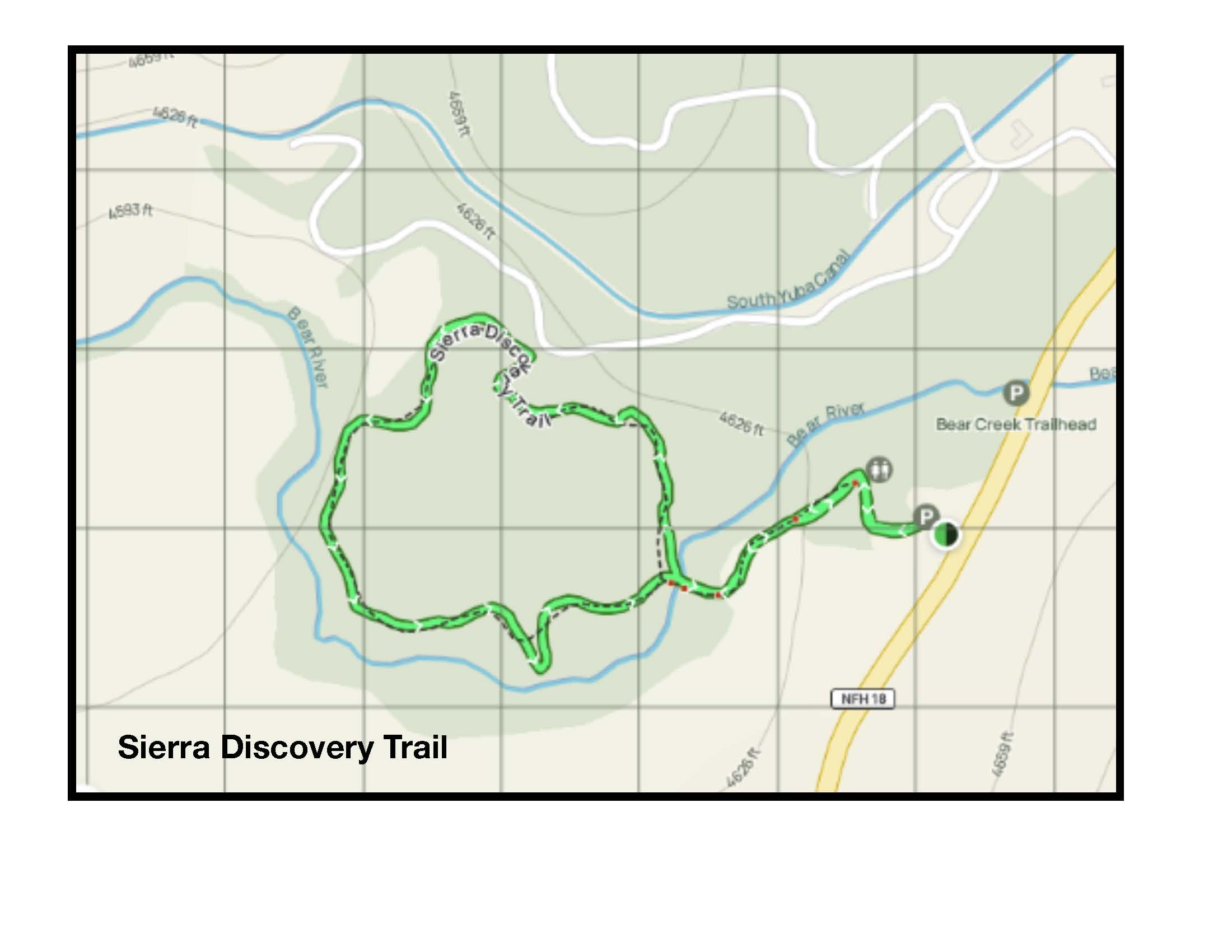
Sierra Discovery Trail

Located at 5,000 feet near Emigrant Pass, Sierra Discovery Trail is a one mile partially paved loop trail meandering through an old growth conifer forest. Bear River also runs adjacent to the trail providing an opportunity to see an American Dipper. The trail surface can be covered with forest debris and several sections are fairly steep. Strong power wheelchairs are fine but this is not a good location for manual wheelchairs or individuals using walking assistance devices, such as walkers or canes. This location provides an opportunity to see birds not readily present in the valley like Brown Creepers and White-headed Woodpeckers. Parking is free and there is one van accessible handicapped spot. Restrooms are also accessible.